Tweeting at #gistribe today
Posted by G.P. in Uncategorized on July 15, 2015
Edited to add: Hey if you missed out on all the color-theory, cartography tips, map examples, and mapions (map + minion) then head over to @wildlifegisgirl’s storify to see all the tweets for the #gistribe chat in one place! I was honored to be asked to be a featured guest for the chat and had a lot of fun. Thanks everyone!

The #gistribe people asked me to speak on cartography today at 12:00 PT. These typically run about one hour. Follow along with us on twitter and be sure to ask a few questions and post some of your favorite map techniques.
for all newcomers
Posted by G.P. in Cartography Profession on June 14, 2015
I don’t care how many mistakes a cartographer makes. I care about what those mistakes might lead up to if the person keeps trying and experimenting: perhaps a world-view changing map that makes a huge difference to human welfare, to the environment, to science, or to happiness in general!
To be protectionist about ones’ profession when one is at the top is to cover up fears. Fears that professional truisms that you once held dear will be upended. Fears that naive mistakes will ruin the world (or worse-that naiveté will result in creative advances that you yourself didn’t discover!). Or any myriad other fears.
To be protectionist of the principles of your profession, to denigrate those who make mistakes, and to ignore creative enhancements just because they haven’t yet made it into an approved text or some such accepted measure of correctness is to declare that you believe there is no improvement to be made to the current accepted state of knowledge.
Naysayers live it up for a short while, if they’ve made it far enough. But they don’t stay there long if they don’t make room for the up and comers. Up and comers don’t have to look like them, act like them, or make their contributions in the same way. Don’t let the naysayers get you down. You have the potential to change any of a number of things in the cartography profession that need shaking-up.
Could you imagine someone who is truly a genius, someone like Richard Feynman perhaps, getting angry that a scientist misunderstood or misused a principle? He could have held an attitude of admonishment for those who knew less than himself. But instead he thought hard about how to teach better.
And if you make mistakes along the way? Roger Schank says, “we need to reason logically from evidence we gather, carefully consider the conditions under which our experiment has been conducted, and decide when and how we might run the experiment again with better results.”
But please, don’t stop experimenting.
Introducing Kids Map It
Bright Rain Solutions and I put together a fun little project called Kids Map It in our spare time and we’d be glad if you took a peek at it and let us know what you think. Please spread the word about if you think it could be useful for the little ones in your lives or in educational programs that you help with.
Warning: It might go down. It’s on a free instance. It’ll be upgraded to handle more traffic if that becomes a problem–and what a nice problem it would be.
***For now the site is best viewed on a largish screen, not a small netbook screen or phone.***

Goal: Our goal was to make something so easy that the youngest could use it (drag and drop!) but with a detailed enough map for everyone’s needs. It’s bright, but not garish, and intentionally devoid of the complexity of other sites. We had one job! (And hopefully achieved it though feature enhancements are in the works.)
Caveat: It’s early days on this so please let us know what needs to be better!
Specs:
- collaboration made possible by GitHub
- jswizardry via JQuery, OpenLayers 3
- use of icons by flaticon — we’ll add more soon
- customization of a free bootstrap template called Grayscale by startbootstrap
- styling of basemap coded in MapBox Studio and map hosting via same
- served up via AWS free tier–if it breaks, that’s why

Edited to add more unexpected uses:
.@PetersonGIS @BrightRain Fun for all ages! pic.twitter.com/wd2YmLaKbL
— Keith Jenkins (@kgjenkins) June 11, 2015
Recency Bias in Mapping, an Exploration
Posted by G.P. in Cartography Profession, Design on May 27, 2015
I’ve been thinking about recency bias lately. In finance, recency bias is the problem whereby people think that securities trends from the recent past will continue into the future. Instead of focusing on market fundamentals or buy-and-hold strategies, people tend to jump on bandwagons instead, which works until the cycle changes.
Recency bias also applies to many other aspects of human behavior, so how might it apply to map design? One way it applies is that, until the cartography landscape was disrupted around the late 2000s, people tended to make all their GIS maps very similarly. I say “GIS maps” because there were some people making well-designed maps with Illustrator and other design tools before that but the GIS people, for the most part, hadn’t caught on to those skills or those techniques.
Along came some new tools like TileMill (now MapBox), an influx of design-oriented mappers to the field, and new and interesting datasets to map, and suddenly the bar of map design was raised. I predicted this in the 1st edition of GIS Cartography in 2009. Those who were assuming that GIS map design would remain the same were creating increasingly obsolete visualizations.
Let’s show this by example.
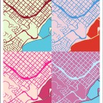
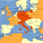
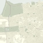
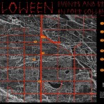
Prior to the late-2000s disruption, we frequently encountered maps that appeared to be slapped together, often with a multitude of diagonal hashes making one feel rather dizzy like in the map shown below. These maps would contain some superfluous details to meet edge-cases (observe the grid-like layer in this map example) and would omit basemap information such that no underlying geographic context could be ascertained. Now, admittedly, these were not always the fault of the map maker. Indeed, the edge-case layers would have been included at the behest of some boss who was the only one who wanted to see that information. Similarly, the basemap information would be omitted due to a lack of availability of that kind of information.

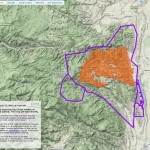
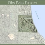
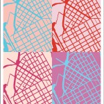
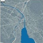
Thankfully we see many fewer of the types of maps shown above and many more of the maps shown below. In this map we have geographic context, gleaned from a nice and subtle baselayer of buildings and streets along with some very nicely done trees. There is some hashing but it comprises a small minority of the overall space. Interestingly, this map manages a significantly better visual experience with much more information. The richness of information makes it both more functional and more beautiful.

What kind of recency bias in mapping do we see today? What kind of recency bias is affecting your map designs? Could an adherence to established practices be holding back your cartographic potential?
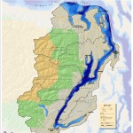
Portfolio, Map Gallery
In addition to authoring books, giving talks and workshops, and creating tutorials, I make maps! Here is just a small selection.


Colorado Geo Meetups, Groups, and Lists
Posted by G.P. in Cartography Profession, Education, Uncategorized on May 6, 2015
Are you a Colorado geo-professional who would like to do some networking while learning more about all things spatial? I recently put together this list of resources for those residing in our state–along with a couple of more general twitter groups–and wanted to share it on the blog. Anything I left out? Please tweet me or write a comment.
Meetups:
Maptime Boulder. Evening gatherings to learn together, sometimes OSM focused. Beginners welcome.
GeoDev Meetup Group. Run by Esri. Typically in Fort Collins at the Rio.
NoCo GIS Users Group. Run by Brian Sullivan, presentations and networking. Loveland, Greeley, Fort Collins, the location rotates.
Geospatial Amateurs, Denver. Run by Peter Batty, Brian Timoney, and Nate Irwin. Local pub, evening gatherings, networking time plus a few presentations.
MaptimeMileHigh, This group is just getting started. Evening gatherings to learn together, sometimes OSM focused. Beginners welcome. @maptimemilehigh on twitter for updates.
General code groups/contests:
Women who Code Boulder/Denver.
Lists, etc:
Rocky Rogues. They do “night out” events and also maintain an online job board.
GIS Colorado an active listserve and website.
Twitter groups, non Colorado focused, you can follow along even if you’re not on twitter:
#geowebchat, 1:00 MT on 1st Tuesdays
#gistribe, 1:00 MT on Wednesdays
@PetersonGIS I feel like the Fort deserves a Maptime!
— Sean Gillies (@sgillies) May 6, 2015
@PetersonGIS I'm moving to Colorado next month, so this list is very helpful!
— Kiri Carini (@tomatopurl) May 6, 2015
The Books


Recent Comments