Since Thanksgiving is coming up here in the U.S., I’ll be taking a break from blogging for a few days. I hear site traffic is low during this time of year anyway – though I wouldn’t know from personal experience considering this is only the 6th month of the blog. Speaking of Thanksgiving, I want to thank everyone for reading! It has been a lot of fun coming up with topics, writing, and working to get more GIS/cartography products out there that people can actually use.
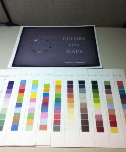
In other news, @LearonDalby printed out his copy of Colors For Maps and arranged it in a way I hadn’t even thought of before. He’s placed all the pages so that the vertical color palettes, which are on the right-hand side of every page, show at once. I imagine this is a good way to get a good overview of all the options. He posted a picture of it (shown below) over on Ow.ly.
I’ll be spending the time between now and my next post trying to figure out things such as: what is the difference between the City of Bremerton’s comprehensive plan and zoning layers? How can I calculate potential buildout in excel instead of ArcMap? How do I convey to meeting participants that the map that is shown has attributes that aren’t shown – I didn’t actually delete anything? And many, many other such things, judging by the mental to-do list. 
Have a very Happy Thanksgiving.


Recent Comments