Archive for category News
Free .style File for ArcGIS with Colors For Maps Purchase
*Those who’ve already purchased the booklet can get the file too – just comment here, email, or DM me on twitter
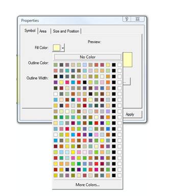
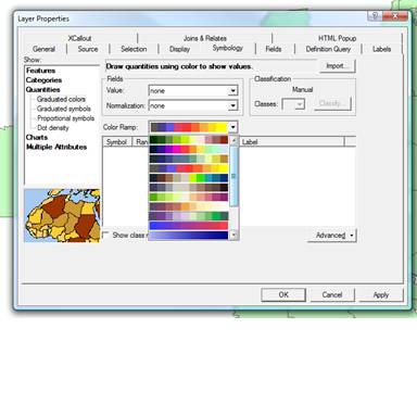
When you purchase Colors For Maps it now comes with a free .style file that you can load into ArcGIS and have instant access to all the colors in the booklet. All the colors in the coordinated and differentiated palettes sections can be selected by their page and color number in the ArcMap color selector. The colors from all three sections can be selected in the color ramps selector as well.
The colors are all organized by the page number that they correspond to in the booklet. I hope that makes them easy to find and use. If you don’t know how to get a .style file to work in ArcMap, here’s a link to a Mapping Center article on how to use them in ArcGIS 10.
You will notice one black and white color at the end of each set. This was the only way to make it so each page was on its own line in the selector box, since the booklet contains 10 colors per page while ArcGIS has room for 12 colors per line.

New and Noteworthy
On ecopolitology.org you’ll find an article about David B. Sparks’ election data animation: Stunning Animated Time-Lapse Map of Red-Blue America 1920-2008. According to Sparks, the map is more telling than a choropleth map because it does not use political boundaries as the organizing unit and instead uses isarithmic shading to show partisan intensity.
The International Cartographic Association has a map of the month feature. For November 2010 they feature the “Atlas of Canada International Polar Year Circumpolar Map.” It’s a circle! Be sure to click the full screen button to see the map up-close.
A map of Facebook friendships was recently produced by Paul Butler. He weighted the lines between cities – had coordinates of the cities and plotted lines between them – according to data on friendship density between those cities. Very interestingly, he apparently did the majority, and perhaps all, of the work in R.
Thanksgiving Break
Since Thanksgiving is coming up here in the U.S., I’ll be taking a break from blogging for a few days. I hear site traffic is low during this time of year anyway – though I wouldn’t know from personal experience considering this is only the 6th month of the blog. Speaking of Thanksgiving, I want to thank everyone for reading! It has been a lot of fun coming up with topics, writing, and working to get more GIS/cartography products out there that people can actually use.
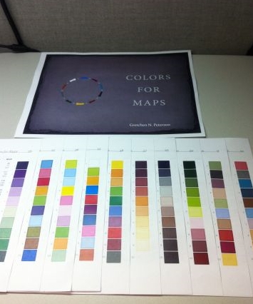
In other news, @LearonDalby printed out his copy of Colors For Maps and arranged it in a way I hadn’t even thought of before. He’s placed all the pages so that the vertical color palettes, which are on the right-hand side of every page, show at once. I imagine this is a good way to get a good overview of all the options. He posted a picture of it (shown below) over on Ow.ly.
I’ll be spending the time between now and my next post trying to figure out things such as: what is the difference between the City of Bremerton’s comprehensive plan and zoning layers? How can I calculate potential buildout in excel instead of ArcMap? How do I convey to meeting participants that the map that is shown has attributes that aren’t shown – I didn’t actually delete anything? And many, many other such things, judging by the mental to-do list. 
Have a very Happy Thanksgiving.
The Colors For Maps Booklet
Posted by Gretchen in Booklet, Color, Inspiration, News on November 2, 2010
Colors For Maps – This takes you to the purchase page.
I’ve been so busy over the last couple of days getting everything set for the debut of “Colors For Maps,” my newest publication. It’s a 40 page booklet containing 30 color palettes chosen for their usefulness in map designs of many types.
So far, these are the review comments I’ve gotten:
“This is well worth the $10 Gretchen is charging for the booklet. Maybe next we can persuade Gretchen to come out with a poster that we can print on our plotters.” Amanda Taub, GIS Analyst, GISP (via the LoneGISPro group)
“I would use this information in this book. We are constantly making quick prints for executives (Governor or Legislature). There is an art and a science to portraying the information appropriately and you only get one brief chance to get it right. We have used [an online color-picking site] for several years…but it doesn’t always give us exactly what we need. This booklet takes the next step.” Learon Dalby, Geo Program Manager, State of Arkansas (via email).
“Just bought it…Nice!” @fgcartographix (via twitter).
For those who have already purchased the booklet, please do let me know either in the comments or via email what you think of it.
Special thanks goes out to the peer-editors, which are listed on the booklet page. But also I need to make sure that my web designer – Becky Dobbins – gets full credit for the wonderful job she did setting up the booklet page and making sure it interfaces with PayPal and Google Checkout (you can pay via credit card with PayPal too) with a seamless and secure check-out.
I’ll write more about the making of the booklet in future posts. For now I am going to sit back, relax, and enjoy this vanilla with vanilla cupcake my husband bought me to celebrate the booklet being done…finally.
Mapbiquity Launched!
My husband, Kris, just launched a new web service called mapbiquity. I’ve been given the okay to announce it on this blog and hopefully get some folks to go check it out!
Of course I am biased but I think it is an absolutely fabulous solution for people who don’t want to tinker with coding but who still want to put a map on their website. You upload your own shapefile(s) and style them – it has a great response time – see a preview of what you’re doing – then export to a couple of lines of html code that you can copy and paste into your own site. You can give it a test drive with some data that is already pre-loaded on there.
Pricing is pretty easy to figure out as it is based on the amount of storage space you need for your shapefiles. He plans to add support for raster data soon. He’s very receptive to comments and suggestions too!
-
You are currently browsing the archives for the News category.
The Books


Recent Comments